


의 설명 Austrian Map mobile
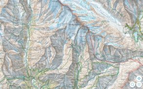
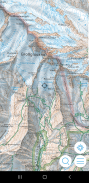
The Austrian Map mobile (AMap mobile) contains the digital maps of Austria including hill shading, geographic names database “Geonam” and the digital elevation model. This digital product of the Bundesamt für Eich- und Vermessungswesen (BEV) offers high quality topographic maps and a user-friendly interface with extensive functionality.
Maps and data available in the Austrian Map mobile:
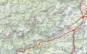
* Overview Map 1:1 Million (free of charge)
* Cartographic model 1:500 000 (free of charge)
* Cartographic model 1:200 000
* Cartographic model 1:50 000
The app contains a map tile contingent of 550 tiles, which corresponds to 550 km ² in the scale 1:50 000 (no specific area, maps free to choose). This allows to test the capabilities of the AMap mobile in a specific area. Additional areas may be downloaded at will.
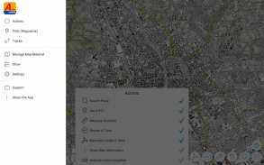
Functions of Austrian Map mobile:
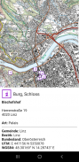
* Search by toponym or search by coordinates
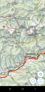
* GPS features: Display of the location, "moving map", compass support, routing along tracks
* Insert, edit and share POIs (Points of Interest)
* Recording and exporting tracks (tracks can be imported into AMap Fly)
* meta data about the used map sheets오스트리아지도 모바일 (AMap 모바일) 언덕 음영, 지역 이름을 데이터베이스 "Geonam"와 디지털 고도 모델을 포함 오스트리아의 디지털지도가 포함되어 있습니다. Bundesamt 모피 Eich - 숙녀 Vermessungswesen (베브)이 디지털 제품은 다양한 기능을 갖춘 고품질의 지형지도 및 사용자 친화적 인 인터페이스를 제공합니다.
지도와 오스트리아지도 모바일에서 사용할 수있는 데이터 :
* 개요지도 1시 1분 만 (무료)
*지도 제작 모델 1:500 000 (무료)
*지도 제작 모델 1:200 000
*지도 제작 모델 1시 50분 000
앱은 550km에 해당하는 550 타일의지도 타일 우발적, ² 규모 1시 50분 000 (없음 특정 영역을 선택하여 무료지도)에 포함되어 있습니다. 이 특정 지역에 AMap 모바일의 기능을 테스트 할 수 있습니다. 추가 지역은 의지에서 다운로드 할 수 있습니다.
오스트리아지도 모바일의 기능 :
좌표로 toponym 또는 검색으로 * 검색
* GPS 기능 : 위치 표시, "이동지도", 나침반 지원, 트랙을 따라 라우팅
* (관심 장소) 관심, 삽입, 편집 및 공유
* 녹화 및 수출 트랙 (트랙 AMap 플라이로 가져올 수 있습니다)
사용 된지도 시트에 대한 * 메타 데이터
Austrian Map mobile - 버전 2.1.3
(20-10-2022)Austrian Map mobile - APK 정보
APK 버전: 2.1.3패키지: com.garzotto.amma동일 카테고리의 앱
좋아할 만한 것...


